
On This Page
The regional transportation system is composed of roadways, transit, pedestrian/bicycle facilities, and freight-focused facilities—with multiple facility types in each group and numerous functions per type.
Regional Roadway System
The current transportation system includes more than 25 thousand miles of total roadway, with more than 170 million miles traveled daily in 2015. The majority of the major roadway system is arterial streets—those which bring local traffic to more regional destinations or freeways. Freeways, including Interstates and other limited-access roads, make up around 10% of the roadway system, but handle more than 40% of daily traffic. Conversely, local roads known as “collectors” comprise almost a quarter of the system, but serve only 7% of daily traffic—mainly at the origin and destination-points. Approximately 180 miles of tollways are located in the region, handling about 8% of daily traffic—an opportunity for future growth in terms of their regional percentage share.
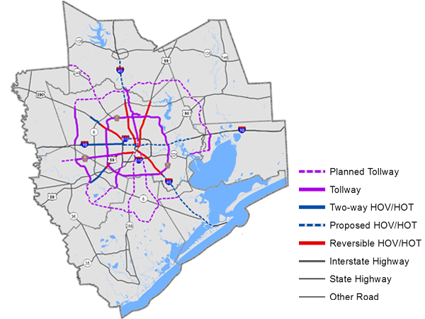
In order to promote the use of mass transit and high occupancy vehicles, “Managed” lanes also known as High Occupancy Vehicle (HOV) or High-Occupancy Toll (HOT) lanes are restricted to vehicles with multiple occupants or charge a fee for use depending on the number of passengers in a vehicle and the time of day. Approximately 100 total miles of Managed/HOT lanes and around 200 miles of Managed/HOV lanes are available on four major regional freeways and account for approximately 900 thousand miles traveled or 1% of travel during peak-period, or rush hour-like, conditions.
Regional Transit System
The regional transit system is composed of seven public transportation providers covering seven counties. The dominant forms of service provided are local bus routes, park and ride/commuter service, demand response, and light rail. Local bus service utilizes different sizes of vehicle depending on the route, and accesses HOV lanes and bus-priority technology where available. Currently, the region’s first dedicated bus lanes are under development parallel to the state’s most congested roadway, West IH 610 Loop. Park and ride service uses parking lots or transit centers as an origin and delivers workers to major employment centers using larger-capacity vehicles. Demand response service depends on contact initiated by the transit user, and may run along fixed routes or implement route flexibility. Light rail service is electric trains running on dedicated track, and differs from commuter-style long distance rail, which runs on tracks designed for heavier rail vehicles. The number of people using public transportation and other alternative modes of travel is increasing after several years of declining ridership, especially in park and ride-style service routes.
![]()
Park and ride lots provide alternative longer-distance commuting services from 34 sites, saving regional congestion from an estimated 20,000 cars. These commute alternatives result in 82% driving to work alone in the region. The light rail system currently consists of one line of 13 miles through the historical core of Houston. Two more lines, adding ten miles to the system, are scheduled for opening in 2015.
Local fixed route and demand responsive transit services will continue to comprise the largest number of transit trips—a service frequently used by older segments of the regional population.
Regional Bicycle/Pedestrian System
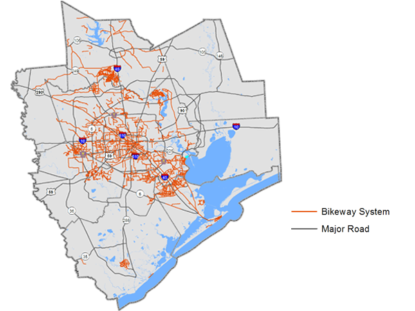
Bikeways are an integral component of the current and future regional transportation system because they provide a multitude of benefits to the region’s public health, quality of life, access to employment and recreational opportunities, and safety.The region currently has approximately 1,215 miles of bikeways, with the City of Houston currently having 300 miles of bikeway, the most extensive network in all of Texas. Based on rate of construction, the region is gaining momentum in creating destinations for walking and biking, such as the Bayou Greenway Initiative, Sugar Land Town Center, The Woodlands Town Center, and City Center in west Houston. Since 2009, H-GAC has coordinated the construction of more than 87 miles of bicycle-pedestrian pathways. As the regional bike network expands, the opportunity for all residents to take better advantage of it as a mode of travel and commuting increases as well. The 2012 ACS indicates that nearly 4,000 people commute by bicycle in the City of Houston, and almost 7,000 region-wide.
The regional pedestrian system consists of all facilities and paths designed to be used at least in part by pedestrians. Details regarding the regional vision for this important mode and specific recommendations can be found in the Regional Pedestrian and Bicycle Vision Plan in Appendix F. In addition, the health benefits of active transportation are referenced in the health planning framework located in Appendix H.
Regional Freight System
Another major function of the transportation system is to move goods and services for commercial purposes. Improvements to the most freight-intensive roadways and infrastructure have potential to benefit both commuters and freight providers. The H-GAC region is an international hub of port traffic, and the Port of Houston Authority ranked as the nationwide leader in handling foreign tonnage in 2014. The Port of Texas City serves major petrochemical producers and refiners along the eastern half of the region. The Port of Galveston, in addition to direct rail service and produce handling, has one of the most robust cruise passenger programs in the country. Port Freeport, in southern Brazoria County, enjoys natural deep-water access and is positioned to benefit long-term from billions of dollars of energy-related investment in its vicinity and cargo handling capacity. There are more than 1,000 miles of freight-carrying railroad track in the region, with two Class 1 railroads (Union Pacific and Burlington Northern-Santa Fe) operating approximately 2,000 trains of all types across almost 1,200 at-grade roadway crossings. Pipelines carrying liquids and gases total almost 21,500 miles—with sizes ranging from less than 10 inches to 42 inches in diameter. Of the billions of dollars of tradable goods that enter Texas every month, the Houston-Galveston region carries 82% by trucks.
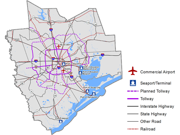
The region’s 26 airports also serve freight needs. Annual air cargo measured almost a billion pounds in 2012, an increase of more than 5% from 2010. This activity was in addition to the 25 million passengers Bush IAH and Hobby handled in 2012. According to the Regional Aviation System Plan (RASP), the 26 airports are expected to grow from 1.9 million operations and 2,938 based aircraft in 2008 to more than 2.4 million operations and 3,839 based aircraft in 2030. This growth is at a slightly higher rate than general aviation in the nation and the state.
Further Reading
The Annual Mobility Report/Progress Reports summarize the yearly changes to our transportation system, and the Vision Newsletters spotlight the monthly high points in transportation planning.